- The submission of the coordinates of the Libyan continental shelf in document A/79/916 (1 July 2025) represents a particularly significant case of lawfare—that is, the strategic use of international legality and institutional mechanisms to consolidate geopolitical faits accomplis.
- By invoking Article 33 of the UN Charter on the peaceful settlement of disputes (which UNCLOS also indirectly references, particularly in Article 38), Libya has chosen to unilaterally submit its outer maritime coordinates without prior delimitation with all neighbouring states. While citing the principle of equity, it in practice rejects fundamental norms of the Law of the Sea.
- The submitted coordinates entirely disregard the rights of islands—a longstanding Libyan position—aligning with Turkey’s stance that Greek islands exert zero influence. This directly supports Ankara’s strategy of imposing a so-called median line solely between continental coastlines.
- Libya’s entrenched claims are also visible in its unilateral and illegal closure of the Gulf of Sirte using a straight baseline, effectively reclassifying the area as ‘internal waters’—a status akin to sovereign land. This manoeuvre extends Libyan influence at the expense of Greece, Malta, and Italy.
- Libya has also proclaimed a Fisheries Protection Zone with no basis in UNCLOS, with a total width of 74 nautical miles, which, south of Crete, reaches and even surpasses the median line.
Point 1 as a Strategic Choice
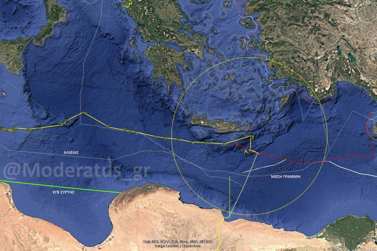
- Point 1, located 12.1 nautical miles from the Greek coast, might have been expected to align with the extension of the red line defined in the 2019 MoU, expressing zero island rights. Instead, it lies north of the MoU, outside the southern projection of Crete’s coast.
- The maximum arc from Point 1 proves it is based on the midpoint only between the continental coastlines of Libya and Greece, ignoring the presence or influence of Turkey—which loses 33 nautical miles from the red line denoting zero island effect. Once again, Turkey proves generous in giving away other states’ rights, handing over Greek maritime claims to Libya, just as it previously handed Cypriot maritime zones to Egypt, Israel, Lebanon, and Syria.
- Although Turkey is clearly directing the process, it seeks to enforce a fait accompli south of Crete through Libyan channels, without appearing as a directly involved actor. Had Point 1 been placed further south, in line with the red line, it would generate Turkish maritime entitlements, thus requiring Turkey to defend them overtly.
- Turkey instead uses Libya as a proxy, assigning TPAO (the Turkish Petroleum Corporation) to conduct exploratory activities in Libya’s name. If Turkey needs to intervene, it will claim to be defending TPAO assets on behalf of Libya. If retreat becomes necessary, it will not appear as a retreat from Turkish territory or claims.
According to the submitted list of coordinates, the northern boundary of the Libyan continental shelf begins (east to west) with points B and A, which form the eastern and western endpoints of the maritime boundary agreed under the 2019 Libya–Turkey Memorandum of Understanding. From point A, the boundary extends to the alleged median line between the mainland coasts of Libya and Greece, marked by points 1 to 12.
Libya’s Positions in Document A/79/916
- The 2019 Libya–Turkey MoU is valid and officially registered with the UN.
- Greece and Egypt have no rights over the maritime zones covered by the MoU.
- The 2020 Greece–Egypt agreement is considered invalid and contrary to international law and equity.
- Greek and Egyptian energy exploration licences violate Libyan maritime rights.
- Greece’s 2025 Maritime Spatial Plan (MSP) infringes upon the Libyan continental shelf.
- Greece’s EEZ proclamation in the Ionian Sea (April 2025) is claimed to violate international law.
- Libya rejects the so-called ‘maximalist’ claims of Greece and Egypt.
- It expresses readiness to negotiate, based solely on the principle of equity.
Note on Lawfare
Lawfare (law + warfare) refers to the use of legal tools and institutions to achieve geopolitical ends, as typified by Turkey’s strategy:
- Unilateral legal actions (e.g. submission of coordinates)
- Selective interpretation of international law
- Creation of legal pretext through agreements with compromised entities (e.g. the Libyan government under Turkish influence, the pseudo-state in northern Cyprus, or the administration in Idlib)
- Undermining the legitimacy of competing actions (e.g. exploration licences granted by Greece and the Republic of Cyprus)
- Blocking delimitation agreements involving Cyprus–Lebanon, Greece–Albania, and others
Cyprus as a Model for Implementation
Turkey first developed the lawfare model in Cyprus:
- It unilaterally recognised the pseudo-state as a ‘sovereign’ entity.
- It concluded a bilateral ‘agreement’ on the delimitation of the EEZ between Turkey and the ‘TRNC’.
- It granted TPAO licences for exploration south of Cyprus.
- It invoked the ‘rights’ of the pseudo-state in maritime zones which, according to the Turkish Cypriot narrative, have reduced influence in the north and south and no influence at all along the remaining coasts (west, east, northeast, southeast).
Exporting the Legal Construct
Turkey attempted to export this legal model to third countries:
- Through generous concessions at the expense of Cyprus, it proposed maritime agreements to Egypt, Israel, and Lebanon—without success.
- It succeeded in blocking the Cyprus–Lebanon and Greece–Albania agreements through political pressure and deliberate disruption of negotiations.
- It is now attempting to reach a delimitation agreement with the Syrian regime under Jolani (Al-Nusra) in order to fabricate a pseudo-legal consensus that denies any maritime effect to Cyprus.
Libya as a Field for Exporting the Model
- Signing of the MoU (with a formally recognised government)
- Assignment of exploration rights to TPAO based on existing mid-distance parceling
- Submission of a full set of coordinates to the UN, laying the groundwork for new parceling to be allocated to TPAO
Purpose: To establish a fait accompli of zero island effect, using Libya as a proxy to legitimise the Turkish maritime doctrine (Mavi Vatan).
Ultimate Goal: To undermine Greece’s maritime rights across the southeast Mediterranean and half of the Aegean, amid continued pressure and destabilisation of Greece’s eastern islands.
The overarching strategy aims to internationally entrench the notion that islands are not entitled to maritime zones (EEZ or continental shelf).
Conclusion
The challenge for Greece and its allies is not only to reject these artificial legal constructs, but to:
- Recognise the underlying mechanism behind their creation
- Respond in a timely and strategic manner,
- Neutralise them across all domains: political, legal, operational, and informational
Exposing Turkish lawfare is not merely a reaction—
It is a strategic imperative to defend sovereignty and uphold international law.


