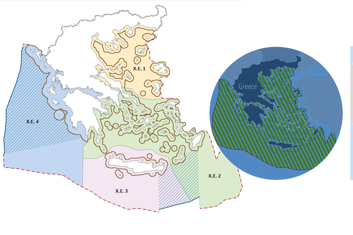
They agonizingly insist that this is not an exercise of sovereignty! It took a CJEU ruling for Greece to release the marine plots map. After waiting for the country to be condemned by the EU Court of Justice, to which the Commission appealed, they printed and published a map of the maritime plots!!!
In the announcement it is clarified that this action concerns an essential obligation of our country towards the EU, and it is stressed: ‘The Marine Spatial Planning and its specification with a map is a record of activities in all maritime zones of the country, not an exercise of sovereign rights.
In another part of the communication ,it is also stated that:
The process of defining maritime zones has a different scope from maritime spatial planning , which is the process by which the competent authorities of the Member States analyse and organise human activities in these maritime areas in order to achieve ecological, economic and social objectives.
Consequently, the map depicting Greek maritime spatial planning does not constitute an EEZ delimitation.
The act establishing the National Spatial Strategy for the Marine Area (NSSP), which specifies and maps the country’s Marine Spatial Planning (MSP), was issued today on the initiative of the Ministry of Environment and Energy in cooperation with the Ministry of Foreign Affairs and the relevant Ministries.
This is an important initiative, as for the first time our country is setting the rules for the organisation of maritime space. The MPA constitutes a holistic spatial framework and is a prerequisite for the successful development of a blue and circular economy, clearly reflecting the human activities that can take place in all maritime zones of our country, with respect to the urgent need to protect the environment.
The approach taken in the preparation of the FSAP has synthesised often conflicting social, economic, energy and environmental parameters in order to serve a number of interrelated objectives, such as the climate resilience of the marine environment, sustainable tourism development, the protection of our cultural heritage and in particular maritime antiquities, the improvement and protection of maritime transport, the exploitation of the country’s energy resources, fish farming and the enhancement of transboundary projects in the marine environment. The MSP takes into account the interactions between land and sea-based activities and emphasises consultation and co-determination of priorities by region through the establishment of Marine Spatial Frameworks.
With the MSP and the MSPF, the Greek State for the first time delineates detailed uses of its marine zones, implementing the obligation arising from Directive 2014/89/EU and exercising the rights stemming from International Law.
The Ministers
Foreign Affairs
George Gerapetritis
Environment and Energy
Stavros Papastavrou
Marine Spatial Planning
Questions & Answers
- (THFS)
It is the first time that the furthest potential limits of the Greek continental shelf (i.e. the full influence of the mainland and islands in maritime zones) are reflected in an official EU regulatory document.
- So what does the map depict?
The maritime areas depicted on the map include the Greek-Italian EEZ delimitation agreements of 1977 and 2020 and the Greek-Egyptian agreement of 2020, and coincide with the boundaries resulting from Law 4001/2011.
As far as non-demarcated areas are concerned, the median line defining the outer limit of the Greek continental shelf is depicted, until the conclusion of delimitation agreements with neighbouring states whose coasts are adjacent or contiguous to the Greek coast.
- So the map depicts the EEZ of Greece in the whole of Greek territory (the Ionian, the Aegean and the Eastern Mediterranean)?
The process of delimitation of maritime zones has a different object from maritime spatial planning, which is the process by which the competent authorities of the Member States analyse and organise human activities in these maritime areas in order to achieve ecological, economic and social objectives.
Consequently, the map depicting Greek maritime spatial planning does not constitute an EEZ delimitation.
- Does it reflect the extension of the Greek coastal zone to 12 nautical miles (in the Aegean and Eastern Mediterranean)?
The extension of territorial waters up to 12 nautical miles is an inalienable right of our country under the United Nations Convention on the Law of the Sea. It is a right which Greece reserves the right to exercise when and as it deems it to be in its national interest, based on the rules of international law.
- How is the preparation of the Maritime Spatial Planning related to sovereignty and the exercise of sovereign rights?
Marine Spatial Planning and its elaboration by map is a mapping of activities in all maritime zones of the country – not an exercise of sovereign rights.
Sovereignty is not an object of planning. It exists and is not affected by it.
- Why is the government submitting the Maritime Spatial Plan now?
The government is closing outstanding issues of the past. It is defending national interests in practice and in a meaningful way, not with communication flares.
- The drafting of the MSP is likely to provoke a reaction from Turkey. So you are abandoning the Greek-Turkish dialogue?
The fact that we are resolving past issues does not mean that we are not pursuing Greek-Turkish dialogue. Just because we disagree does not mean that we are not discussing. Discussing does not mean that we are discounting our positions, and this is demonstrated in practice. Greece wants a positive climate in relations with Turkey and has been in favour of Greek-Turkish understanding on the basis of international law and good neighbourliness from the outset.
Moreover, Maritime Spatial Planning is an essential obligation of our country vis-à-vis the EU, which stems from specific European directives and is part of the achievement of a series of European Strategies, such as the Green Agreement and the European Maritime Security Strategy (EUMSS-EUMaritimeSecurityStrategy).


